Who we are
Apus Telecom Satellite Services GmbH was founded in 2015 with following objectives:
- Planning, procurement and operation of satellite systems.
- Marketing of satellite capacity.
- Telecommunications system operation.
- Application for, management and disposal of frequency usage rights.
Example: offering of filing for geostationary telecommunications satellite
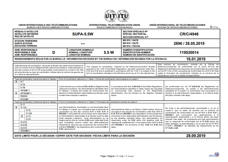
- Satellite Network: SUPA-5.5W
- Filing Authority: German ITU Administration: Bundesnetzagentur (BNetzA)
- Geostationary Satellite Orbit Position 5.5° West, with a “Date of Receipt” by ITU from 16.01.2019, published in WIC/IFIC 2891 (API/C) and 2896 (CR/C)
- For the frequency bands:
- Ka band (FSS, space-to-Earth): 17.3 – 17.7 GHz in Region 1
- Ka band (FSS, space-to-Earth): 17.7 – 20.2 GHz
- Ka band (MSS, space-to-Earth): 19.7 – 20.2 GHz
- Ka band (BSS, space-to-Earth): 21.4 – 22.0 GHz in Region 1
- Ka band (FSS, Earth-to-space): 27.5 – 30.0 GHz
- Ka band (MSS, Earth-to-space): 29.5 – 30.0 GHz
- Q band (FSS, space-to-Earth): 37.5 – 42.5 GHz
- Q band (MSS, space-to-Earth): 39.5 – 40.5 GHz
- V band (FSS, Earth-to-space ): 47.2 – 49.2 GHz & 50.4 – 51.4 GHz
- V band (MSS, Earth-to-space): 50.4 – 51.4 GHz
- W band (FSS, space-to-Earth): 71.0 – 76.0 GHz
- W band (FSS, Earth-to-space): 81.0 – 86.0 GHz
- Above stated frequency bands may be used for Telecommand, Telemetry and Ranging.

Potential coverage area (for example)
- Africa
- Middle East
- Europe
- Parts of South America
- Atlantic Ocean
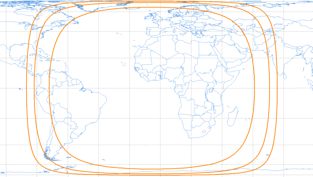
Elevation Contours (from inside to outside): 15°, 5° and 0° (horizon)
Licensing Conditions
Draft Licensing Conditions can be provide upon request.